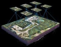
LiDAR is a laser-based technology that has rapidly become one of the most sought-after and important tools of modern surveying. By combining laser technology with powerful GNSS, IMU, and drone technology, as well as other platforms, surveyors can now capture precise 3D data even in complex scenarios, such as dense vegetation, steep terrains, and poor visibility. Due to growing demand for faster, more reliable mapping solutions across construction, agriculture, mining, and urban planning, drone-mounted LiDAR has become a game-changer.
[ai_gcp_planner_pro]
Table of Contents
What is LiDAR? In Simple Terms
LiDAR stands for Light Detection and Ranging, and is a remote sensing laser-based methodology that uses light to measure variable distances to a target object from the sensor.
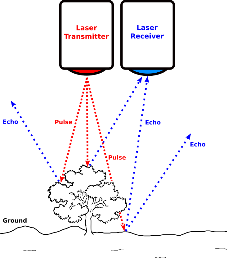
Lidar distance measuring is based on the principle of time of flight (ToF) and the speed of light. The formula is Distance = (Speed of Light × Time) / 2. The distance to a target is calculated by multiplying the speed of light by the time it takes for a pulse to travel from a sensor/ laser transmitter to a target and back to the sensor/ laser receiver. By combining millions of measured pulses and other recorded data, precise and 3D information about surfaces and terrains can be generated.
Lidar can be classified into different categories, which are platform and application areas. Grouping by application area gives examples such as bathymetric lidar, which uses green-based laser pulses for penetrating water and measuring its bottom surface, and topographic laser, which uses near infrared laser to map topographic infrastructure surfaces. By platform, it can be grouped into:
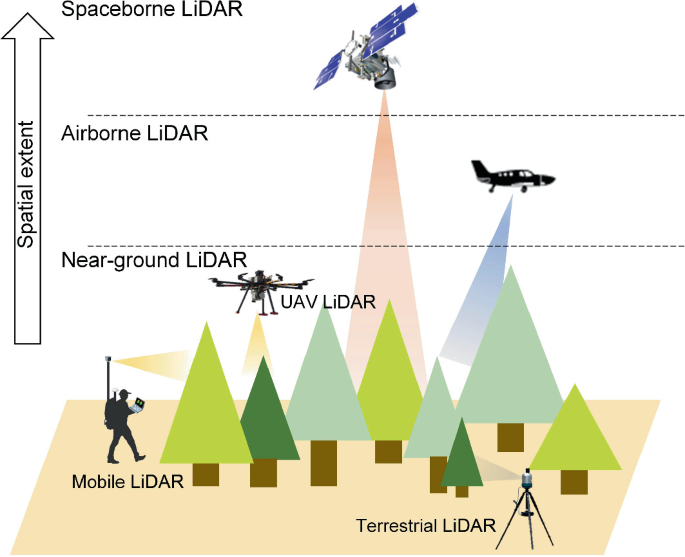
- Airborne Lidar – mounted on drones, helicopters, or aircraft, mostly used for topographic models.
- Terrestrial Lidar – ground-based and stationary high-precision laser scanning, mostly used to map buildings and structures
- Mobile Lidar – mounted on moving platforms such as vehicles, mostly used in road and infrastructure mapping.
- Spaceborne Lidar – mounted on a spacecraft and commonly used for mapping celestial bodies and for space navigation, hazard prevention and mapping.
How Drone LiDAR Works
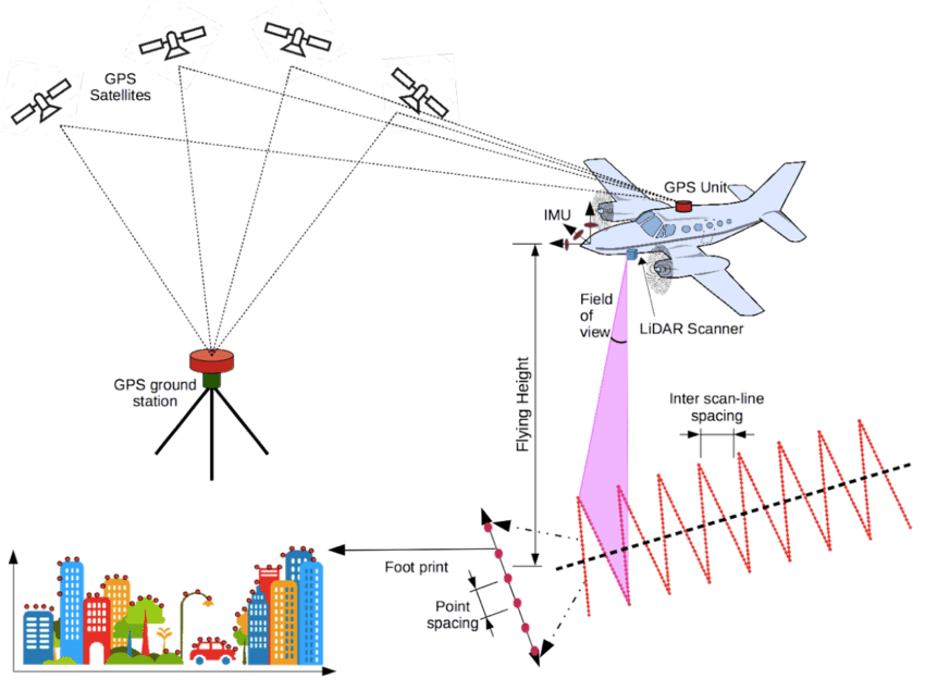
A drone LiDAR system works by combining the global navigation satellite system (GNSS) and the Inertial Measurement Unit (IMU) with a lidar sensor and an onboard computer system. The GNSS system uses satellites to accurately position the aircraft, and the lidar point cloud outputs positions in real-world coordinates.
The IMU measures angular rates (pitch, roll, yaw), velocity, changes in altitude and gravitational forces acting on an aircraft. The onboard computer system records lidar pulses and combines them with GNSS and IMU data to calculate the aircraft’s current position, trigger the camera for colorization (if included), and provide a less noisy, drift-adjusted output.
Lidar vs Photogrammetry
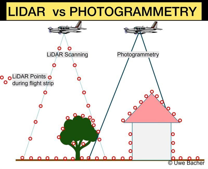
Lidar and photogrammetry use different approaches for mapping. LiDAR uses laser pulses, whilst photogrammetry uses overlapping images from different angles to come up with 3D point clouds and models. LiDAR is an active sensor, whilst photogrammetry is a passive one and works only where there is lighting, whilst LiDAR can even work in the dark.
Another difference, as illustrated in the above diagram, is that LiDAR pulses can penetrate vegetation and trees, making it a preferred choice for mapping dense vegetated areas compared to photogrammetry, which only sees what’s on the surface and does not penetrate dense vegetation. LiDAR is often more expensive and complex to work with than photogrammetry, which is cost-effective and simple. Photogrammetry produces high and richly textured visuals as compared to LiDAR.
The question is often, which one should I choose: LiDAR or photogrammetry? This depends on many factors such as area size, budget, terrain, environment, and project specs and deliverables. In most cases, choose photogrammetry when you want detailed visuals on open surfaces and LiDAR when you want to get a detailed digital terrain model in complex terrain, topography and penetrating vegetation and trees.
Advantages & Disadvantages of Drone Lidar
Advantages
- Penetration through vegetation and other complex features
- High accuracy and precision, detailed 3D point clouds
- Works well in low-lighting areas
Disadvantages
- Often expensive systems and processing needs
- High technical expertise needs and requirements
- High costs of sensors and equipment
- Difficult to interpret on its own with RGB photos, as it is often uncolorised on its own
- Limited penetration in some materials, such as water
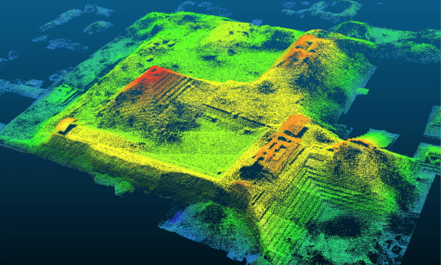
Understanding LiDAR returns
LiDAR returns refer to the reflected laser pulses recorded by the sensor after the emitted laser has hit a target, e.g., trees and buildings. These returns are combined to recreate the 3D models and maps of the scanned objects and environment.
A single laser scan on a varied and complicated scenario, such as urban areas, buildings, or trees, may be reflected multiple times, with each scan being registered as a separate return. The tree crown, branches, and ground may be reflected separately as different returns. Depending on the type of LiDAR sensor, the first and last returns are recorded, three, four, or multiple returns.
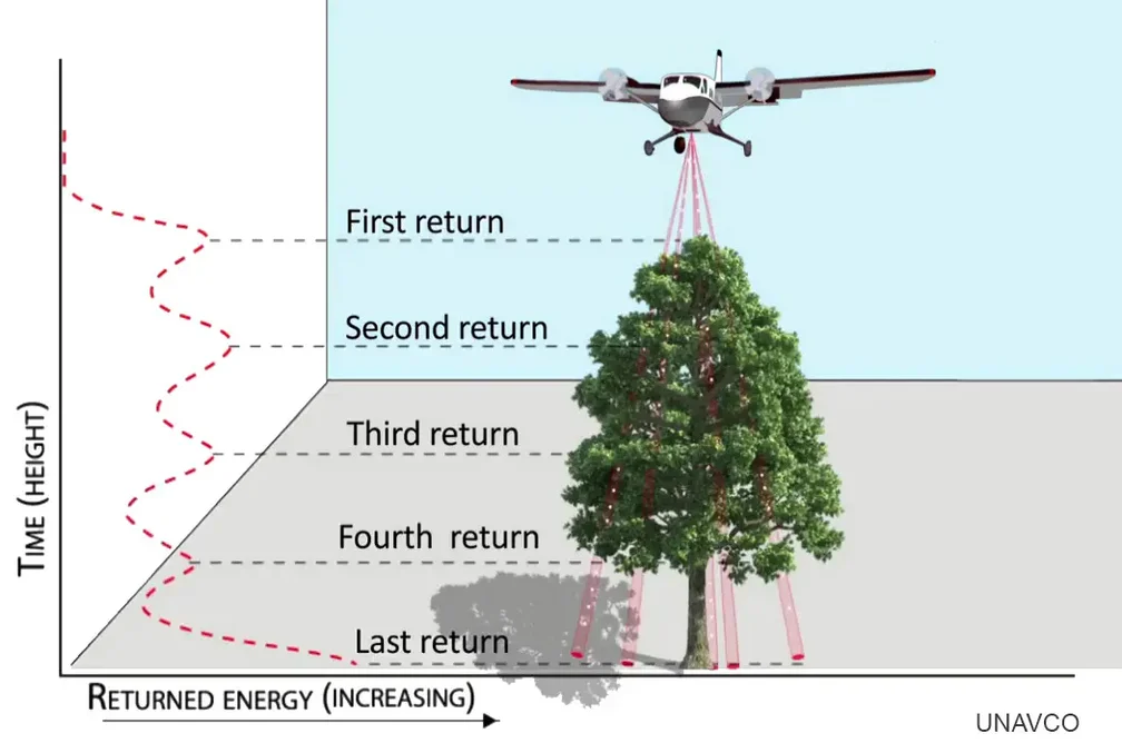
Multiple returns help in getting a better understanding of layered structures and understanding vertical complexities of the environment, enabling more accurate analysis and modelling of the data. This is particularly useful in various fields such as topographical mapping, vegetation monitoring, utilities mapping, and inspections.
Drone-Based Lidar Sensors
The equipment surveyors use is crucial in their work. Use of cheap equipment results in cheap or poor data. When it comes to LiDAR sensors, due diligence is needed to get the best for your budget, accuracy & precision needs, equipment, and many other factors. There are many drone LiDAR sensors you can choose from, and below we will look at some of the common sensors in some drone LiDAR surveys:
DJI Zenmuse L1, L2 & L3
DJI Zenmuse L series has been one of the most used, accurate, and budget-friendly drone sensors that integrate the lidar system and RGB sensors to come up with rich and colorised survey-grade point clouds. From the initial Zenmuse L1 released in October 2020 to the Zenmuse L2 released in October 2023 and now the latest Zenmuse L3 sensor released inNovember 2025, DJI has been on a course to improve its offering. The Zenmuse L2 sensor had system accuracy (Horizontal: 5cm @ 150m, Vertical: 4cm @ 150m) and the Zenmuse L1system accuracy (Horizontal: 10cm @ 50m, Vertical: 5cm @ 50m).
The L1 sensor required a pre-flight IMU warm-up of 5-10 minutes, which the L2 sensor did not require. The L2 sensor was also an improvement of the L1 in many respects, and the L3 sensor is coming in with way better improvements and specs. The Zensmuse L1 and L2 sensors are compatible with the DJI Matrice M300 RTK and DJI Matrice M350 RTK. The Zenmuse L3 sensor is only compatible with the DJI Matrice M400 RTK drone.
Zenmuse L3 Sensor Specs

- Vertical Accuracy: 3 cm (RMSE) & Horizontal Accuracy: 4 cm (RMSE) at 120m flight altitude * Measured under DJI Laboratory Conditions
- Vertical Accuracy 5 cm (RMSE) & Horizontal Accuracy: 7.5 cm (RMSE) at 300m flight altitude * Measured under DJI Laboratory Conditions
- RGB Ground Sampling Distance (GSD) – Average Value: 3 cm (300m nadir flight altitude)
- 1535 nm Laser Wavelength Range
- Up to 16 returns: 4, 8, 16 returns (100 kHz, 350 kHz); 4, 8 returns (1000 kHz) and 4 returns (2000 kHz)
- Dual 100MP RGB mapping cameras and a high-precision POS system
- Maximum laser pulse emission frequency of 2 million pulses per second
- Multiple scanning modes: Linear, Star and Non-repetitive
- Half point cloud thickness as compared to that of Zenmuse L2
Hovermap Emesent ST-X Sensor
Emesent Hovermap ST is a versatile LiDAR mapping multi-payload sensor for drones, vehicles, and handheld applications. It is mostly used in mapping GPS-denied areas such as underground mining shafts & tunnels, indoor and heavily vegetated areas using SLAM-based mapping.
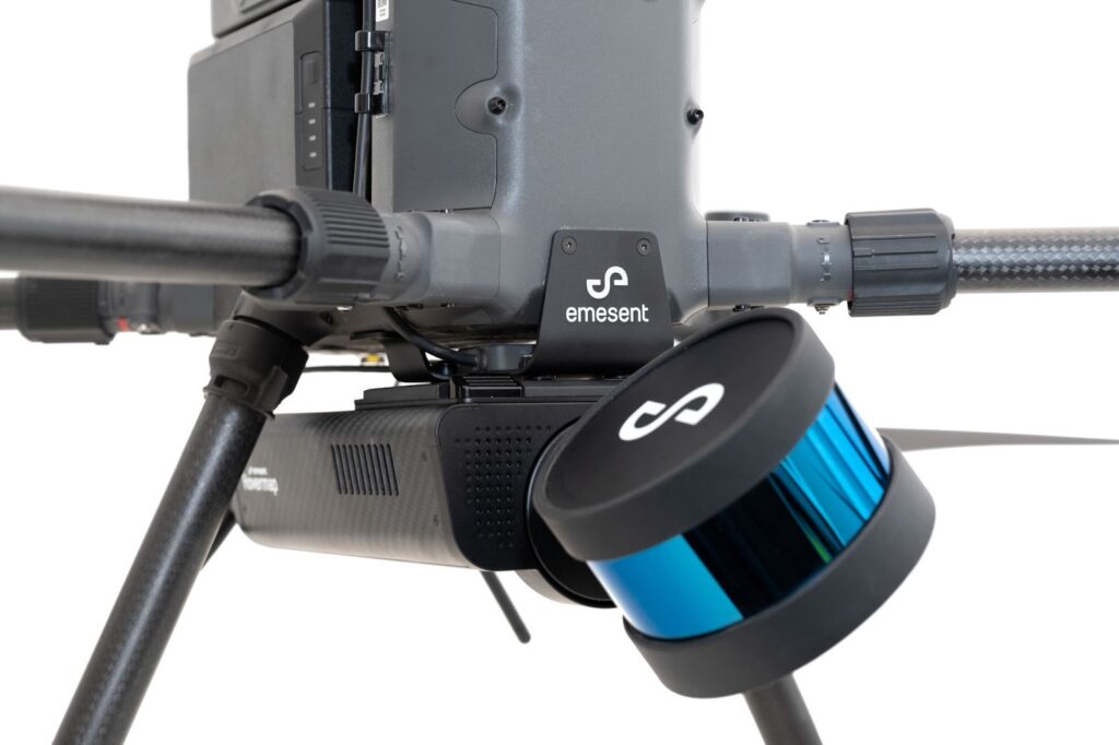
- Up to 300m sensing range
- AI-powered autonomous mapping
- Pilot assist mode for omnidirectional collision avoidance,
- 32 LiDAR Channels
- Mapping Accuracy: ± 15 mm (19/32 in) in general environments ± 10 mm (3/8 in) in typical indoor and underground environments ± 5 mm (7/32 in) isolated change detection capability
- LiDAR Data Acquisition Speed: Single Return Mode: up to 640,000 points/sec Multi Return Mode (3 return): up to 1,920,000 points/sec
Rock Robotic Rock Ultra
High-performance LiDAR sensor with integrated RGB imaging to produce colorized, survey-grade point clouds. It is compatible with the DJI M300/M350, helicopter and other drones. The sensor comes with the following specs:
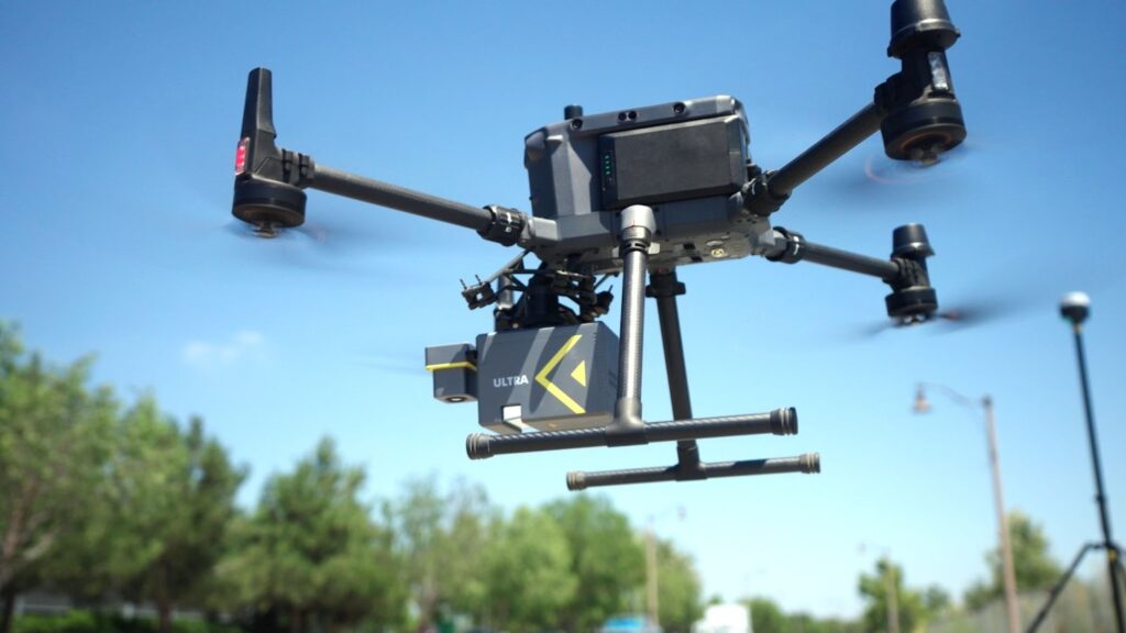
- System Accuracy of 2-3 cm @ 120 m
- Laser precision of 5mm @ 120m
- Measurement rate of up to 1 million points/sec
- 1-2 cm post-processed accuracy
- 1000m Effective Range
- 450m Max Altitude (AGL)
- 45MP / 24MP RGB Camera
- 7 returns
Processing Lidar Data
Lidar processing software takes the raw point cloud from the sensors into actionable 3D point cloud data that is cleaned, georeferenced, colorised, and optimized for deliverables. Many steps and processes are followed in processing the LiDAR data, depending on the sensors used and available software. Further analyses can then be done on processed data to come up with results such as 3D models, digital terrain models (DTM), powerline inspections, etc.

Drone Lidar Application Areas
There are many application areas in which surveyors can use drone LiDAR, and these are not limited to:
- Engineering Survey
- Forest & Environmental Management
- Topographical Mapping
- Powerline Inspections & Management
- Mining Survey
- Emergency Survey
- Urban planning
As LiDAR becomes the in-thing in surveying and geomatics, surveyors must appraise themselves with this latest technology. Stay tuned for more geospatial-related trends, tech, updates and news by subscribing to our newsletter.


