WGS 84 Converter | Lat Lon to DMS & UTM
Accurately converting geographic coordinates is a core task in GIS, surveying, drone mapping, and navigation. This free online WGS 84 Coordinate Converter lets you instantly transform latitude and longitude values into formats used by mapping software, GPS receivers, drones, and GIS systems.
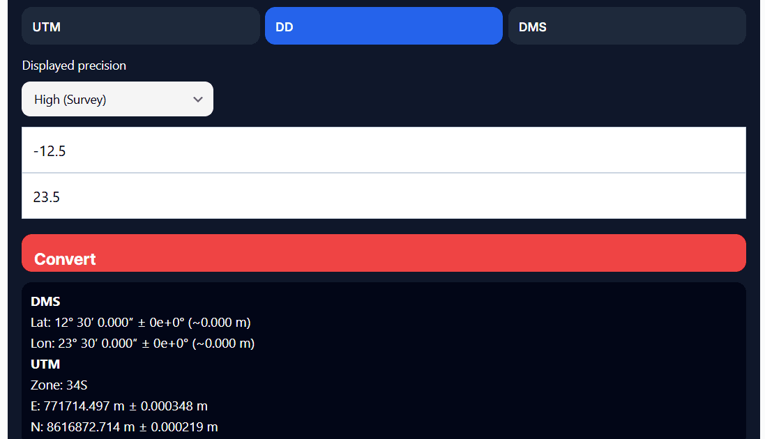
How to Use the Converter
- Enter your Latitude and Longitude in Decimal Degrees or DMS format.
- Choose your desired output format: Decimal, DMS, UTM
- Click Convert and view results immediately.
- Copy or share results for use in your mapping or GIS projects.
This tool works entirely in your browser – no data is uploaded to a server, ensuring privacy and speed.
WGS 84 (DD ↔ DMS ↔ UTM) Converter
Why Accurate Coordinate Conversion Matters
Geographic positions are used across many disciplines:
- Surveying & land measurement
- GIS and spatial analysis
- Drone flight planning & mapping
- Navigation & outdoor applications
- Engineering and construction workflows
Even small coordinate inaccuracies can result in meter‑level errors on the ground, so using a precise converter that handles UTM zones and hemispheres correctly is critical.

Supported Coordinate Formats
Our converter supports:
- Decimal Degrees (DD)
- Degrees, Minutes, Seconds (DMS)
- UTM (Universal Transverse Mercator)
Each conversion preserves positional accuracy and automatically handles UTM zones and hemispheres.
Accuracy, Datum & Projection Notes
- All calculations are based on WGS 84 (EPSG:4326)
- UTM results include the correct zone and hemisphere
- Decimal precision supports survey-grade use
- No browser-side approximations or shortcuts
⚠️ When working with older national datums or legacy systems, always confirm transformation parameters.
UTM Explained (User‑Friendly)
The UTM coordinate system divides the Earth into zones so that locations can be expressed in meters (Easting and Northing), which is ideal for calculating distances and areas in mapping and GIS. This converter automatically detects the correct UTM zone and hemisphere for your coordinates.
Common Mistakes to Avoid
A frequent error is assuming that latitude, longitude, and UTM are interchangeable. They are not.
Latitude and longitude describe positions on a globe, while UTM projects those positions onto a flat grid in meters. This is why conversion must be done correctly, especially for distance, area, and engineering work.
What is the difference between Lat/Lon and UTM?
Latitude and longitude are geographic coordinates, while UTM is a projected coordinate system that uses meters, making it more suitable for distance and area calculations.
Is this converter suitable for professional use?
Yes, this tool delivers accurate WGS 84 transformations suitable for most professional workflows. For survey‑grade legal work, always verify with certified GNSS hardware and official transformation parameters.
Is this converter suitable for professional use?
Yes, this tool delivers accurate WGS 84 transformations suitable for most professional workflows. For survey‑grade legal work, always verify with certified GNSS hardware and official transformation parameters.
Does this tool work worldwide?
Absolutely. WGS 84 is a global coordinate system used worldwide.


