High-accurate drone surveys are fundamental to cartography, engineering design, and precision agriculture. Higher spatial accuracy results in maps, models, and measurements that more closely resemble the real world, helping professionals make accurate, data-driven analyses and decisions. To maximize the effectiveness of your GCPs, they must be properly positioned; having too few can lead to imprecise measurements, while having too many can skew the overall outcome. Below we take you on how you can plan your GCPs for accurate drone surveys.
What Are GCPs?
GCPs are defined as visible ground markers with real world or known coordinates; that are used in anchoring the aerial image to the real world. GCPs help in achieving centimeter-level absolute positioning accuracy in orthophotos. They are also important in correcting camera distortions such as translation, rotation and scale in drone image processing software. They can be measured in the field or determined from other sources, such as old maps and known points.
GCPs are crucial for achieving centimeter-level positioning accuracy. These precisely measured ground markers anchor aerial images to the real coordinate system, correcting for GPS bias and camera distortion. By strategically deploying GCPs, UAV mapping can generate high-precision orthophoto maps, digital elevation models, and 3D maps, widely used in engineering surveying and agricultural analysis.
GCPs vs Checkpoints
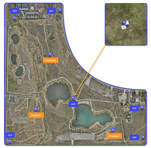
They are the same thing on site , as they are all visual references on the ground with accurate known measured coordinates. The only difference is that the GCPs are used to georeference whilst the checkpoints are used to compare the model to the control. GCPs are used during the processing in the software whilst Checkpoints are used post processing. As a rule of the thumb, not all control points surveyed in the field should be used as GCPs but some should be reserved and used as Checkpoints.
Pre – survey Planning
Pre-survey planning helps in budgeting, improving operational efficiency, minimizing errors and reworks. It is a very critical process in having accurate drone surveys as it involves the number, distribution, size, placement, types, accuracy & precision and coordinate system of the GCPs to be used for the project.
Distribution and Placement of GCPs
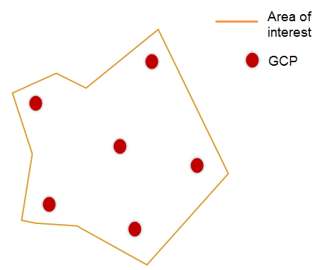
The GCPs should be well distributed across the survey area. The GCPs must be evenly distributed (for consistent accuracy) with likely placement near the corners or edges and centres but not too close to the end of the survey area to ensure good visibility. Terrain changes should also be factored in GCP planning and the rule of the thumb will be to include a GCP whenever there is abrupt change in terrain and that they should be evenly distributed across the same terrain. The GCPs must be placed in areas where they are fully visible from the drone during data capturing, i.e for example in open spaces away from buildings and trees to avoid obstruction.
Number of GCPs
The quantity of the GCPs to be placed are determined by many factors such as the size & shape of the area and the drone survey method. Where the drone survey is not being corrected by post-process kinematic (PPK) or real-time kinematic (RTK) methods, more GCPs will be needed to get accurate results. The output coordinate system also determines the number of GCPs; a coordinate system with known, accurate transformation parameters requires fewer GCPs compared to an unknown, custom coordinate system. The ASCE (American Society of Civil Engineers) and ASPRS (American Society for Photogrammetry and Remote Sensing) standards do not set a mandatory minimum for GCPs; they emphasize required positional accuracy which determine GCPs’ number and distribution per project.

Some academic studies have suggested the optimal number of GCP. Soo-Bong Lim mentioned that 10–12 GCPs are appropriate per 100 ha. Yong-ho Yoo and colleagues classified the number of GCPs into 0, 3, and 6. They reported that no significant difference exists in the deviation of the horizontal accuracy, depending on the number of GCPs. In contrast, the deviation of vertical accuracy decreased as the number of GCPs increased. Bu-yeol Yun and colleagues reported that stable accuracy could be achieved when eight to nine GCPs are used to determine the precise position.
Seung-woo Son mentioned that two to three GCPs should be set per 1 ha to obtain a 3D model with high accuracy, although the number may differ depending on the flight altitude. Another academic study also found that installing over 100 ground control points (GCPs) in a 12 km² area allows for high accuracy with three or fewer GCPs per 100 photographs.(a total of 2514 photographs). Patricio Martínez-Carricondo and colleagues reported a GCP density of 0.5–1 GCP per hectare is necessary.
Recommendations From Different Drone Softwares
Different softwares also have different workflows and recommended methodologies for determining the number and placement of GCPs and it is important to research the one that you will be using. Below we look at the different drone software recommendations:
Pix4D Mapper
- A minimum of 3 GCPs is necessary for reconstruction, with 5 recommended
- For large projects, 5 to 10 GCPs suffice; more do not significantly increase accuracy
- In complex topographies, additional GCPs enhance reconstruction accuracy. It’s best to use at least 5 GCPs, each in 5 images, to reduce error in scale and orientation
- GCPs should be evenly distributed across the landscape and not placed at the edges to ensure visibility.

Drone Deploy
- A minimum of 4 GCPs for non RTK/PPK maps
- Recommend 1 GCP for every 60 drone images for non-RTK/PPK drones
- Recommend 1 GCP for every 200 images for RTK/PPK enabled drones
- At least 1 checkpoint per GCP map
While there is no universal agreeable common number for the expected GCPs, but often the bigger the survey the more the number of GCPs. RTK and PPK methods have greatly reduced the number of GCPs and checkpoints needed for any survey in some instances bringing the need to zero but even though GCPs and checkpoints are still recommended for accurate models.
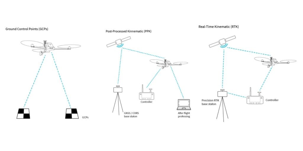
GCPs (Ground Control Points): Ground markers with known coordinates used to match drone imagery with real-world geographic locations.
RTK (Real-Time Kinematics): Real-time correction of GPS data during flight for high-precision positioning.
PPK (Post-Processing Kinematics): GPS data correction after flight to maintain consistent accuracy even in areas with weak signal.
In another study that investigated the effects of GCP placement and the surrounding environment on the estimation of forest information by UAV-SfM; findings suggested that in UAV-SfM-based forest resource surveys, especially for tree height estimation, both the number and placement of GCPs, as well as the surrounding environment, are crucial in enhancing estimation accuracy.
Planning Software
GCPs planning is typically done with general mapping tools like Google Earth Pro, QGIS, etc that essentially allows users to import the survey boundary, view the satellite image or map and terrain of the area. This allows for a near real time view of the area to determine provisional placement and distribution of the GCPs. In Google Earth Pro, the provisional GCPs can be placed as placemarkers then later exported as KML or any other navigation file for easy tracking and placement.

GCP Survey & Measurement
Now after planning the GCPs, the next stage is getting in the field, place and finally measure them. The accuracy of the GCPs is also to be considered and is mostly guided by the output accuracy requirements and mainly following the rule of the thumb that the GCP accuracy should be better than the expected output accuracy.
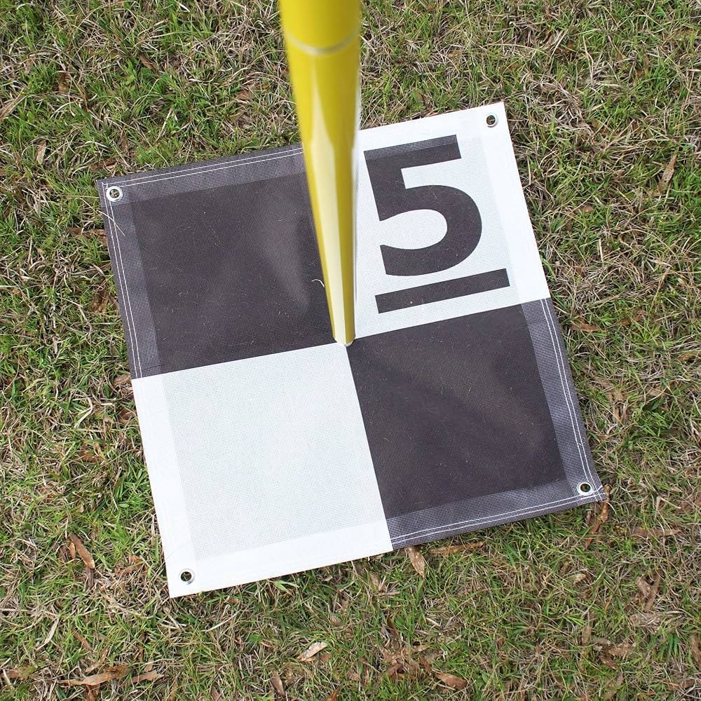
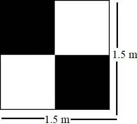
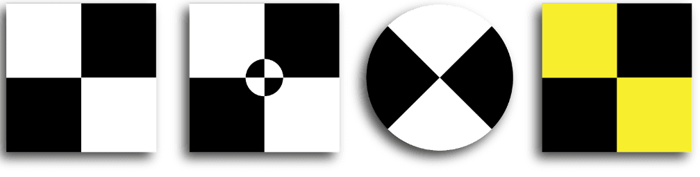
Another critical aspect to look at is the size of the GCP target on the ground, which must be at least 5 to 10 times the dimensions of the GSD to ensure clear visibility and marking on the images during processing. GCPs can come in different specs, sizes and dimensions and construction but in all they must be clearly marked with a large visible intersection and intersection point. The GCPs can be measured in the field by survey methods such as GPS systems or total stations. Below are some of the designs and layout of GCPs that you can use for your drone survey projects:
The GCPs should be planned and placed on safe positions and on areas that are easily accessible to the ground and aerial surveys. They should also be safe from tampering, vandalism and positional shifting between the ground and aerial survey time periods.
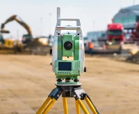
The GCPs must be surveyed and recorded in a consistent coordinate system for each project with appropriate high precision survey equipment and methodologies (RTK, PPK, GNSS and Total Stations).
Capturing Aerial Data
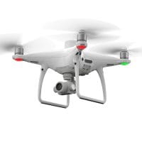
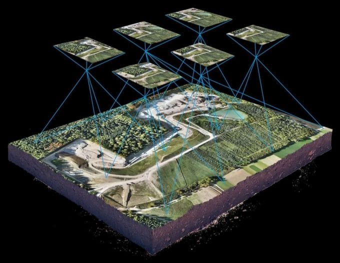
After the GCPs planning and placement, then comes the data capturing part. It is now time to fly your drone over the survey area. It is important to ensure that the right parameters are set such as flying height, overlap(side and frontal), speed and other basic and advanced flight parameters.
It is recommended to do your flights during calm weather and optimal lighting conditions to ensure high quality and consistent results. The overlap settings are typically set at 70-80% front and 50-60% side overlap but can be more depending on the project. Another critical parameter especially on big projects is to maintain a consistent flight altitude as it helps in giving more accurate results and minimizing distortions.
Processing and Integrating GCPs
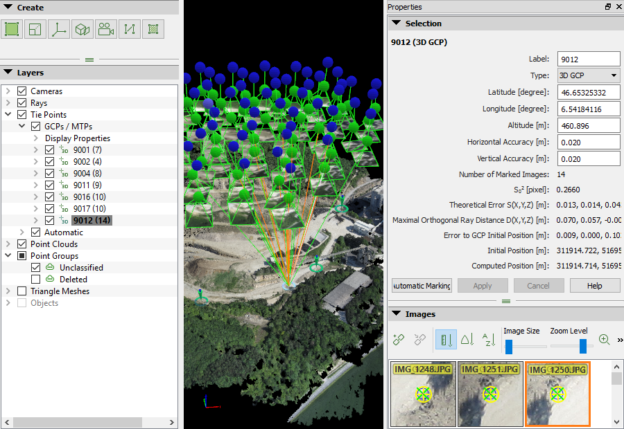
The surveyed GCPs and checkpoints can be imported and integrated with the captured images into the processing software such as DJI Terra, Pix4D, Agisoft Metashape and WebODM. In the software the GCPs and Checkpoints can be tagged and processed. After processing, you check the residual errors and accuracies and see if there is need for reprocessing. If the GCPs and Checkpoints pass the accuracy test, then further processing can be done and analysis and results of the deliverables can be done.


