Physical Address
304 North Cardinal St.
Dorchester Center, MA 02124
Physical Address
304 North Cardinal St.
Dorchester Center, MA 02124

Necessity is the mother of invention, so is the story of one recent University of Zimbabwe GIS graduate, Tinotenda Dinhidza who after facing connectivity and positioning challenges on some field work in a remote area of Zimbabwe decided to come up with a solution for offline data collection.
Tinotenda Dinhidza is a dedicated Geographical Information Science (GIS) analyst and web developer, holding a BSc (Hons) in Geographical Information Science and Earth Observation. He is the sole developer behind TGIS Collector, an innovative mobile application specifically designed for offline data collection in remote regions. Tinotenda has a wealth expertise in remote sensing, spatial analysis, programming and has a strong focus on developing user friendly solutions for enhancing data management and decision making.
“The inspiration for TGIS Collector came during a field visit to a farm in a remote area of Makonde district, Zimbabwe. Although the visit wasn’t focused on data collection, we found ourselves needing to capture farm data and location information. Without GPS and with poor network connectivity, we struggled to accurately capture boundaries and other details. This experience motivated me to create a mobile app that could capture all geometries offline, specifically for use in remote areas.”, shared Tinotenda.
Just like any programming or development project, it wasn’t without challenges from optimizing the app for offline use, creating a user friendly experience for online use and others. ” Since users would be tapping on a mobile device instead of clicking with a mouse, I implemented a crosshair icon to enhance accuracy when adding nodes. As a learner with a passion for development, these challenges were valuable learning experiences.”, he added.
The main objective was to develop an app that works efficiently offline, allowing users to capture point, line, and polygon data without relying on internet connectivity. Initially the app was just to be a simple and intuitive interface allowing offline data collection in the field but later an online mode to enhance functionalities, additional features and visualisations were added to access when internet connectivity is available. This then makes the app, your go to app for online and offline GIS data collection.
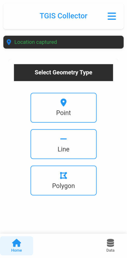
There are many collector apps out there and you might be wondering why you must choose the TGIS Collector app. TGIS Collector stands out as it offers both offline and online functionalities. It allows users to capture all geometries (points, lines, and polygons), with customizable forms, making it versatile for various fields. The app also includes an online mode with satellite view for digitizing data, ensuring users can capture and visualize information easily. Additional features include capturing geotagged pictures, user-friendly data saving and sharing options, and a commitment to continuous updates with new functionalities.
1. Geometry Selection – Supports Point, Line, and Polygon types for data collection.
2. Mode Selection – Online Mode: Collect data using a map with an internet connection. – Offline Mode: Initially developed for use in areas with poor network connection, allowing data collection without internet access.
3. Quick Capture – One-tap location capture with automatic feature naming.
4. Flexible Capture – Detailed data entry interface with customizable input fields. – Real-time coordinates and accuracy display. – Photo attachment capability for points.
5. Data Management – View, edit, and delete captured features (points, lines, polygons). – Export options: CSV, GeoJSON, KML.
6. Customization – Custom input forms for different geometries. – Light and dark theme options.
7. Privacy & Security – All data stored locally on the device. No third-party data transmission.
8. Troubleshooting Support – Guidance for common issues and errors.
9. Server Connectivity – Can be connected to an external server or database upon request.
The is currently only available on Android is not yet on play store but can be downloaded using the following link.
https://tgis-collector.en.uptodown.com/android
https://apkpure.com/tgis-collector/com.tgiscollector.app
Download the app and enjoy the ease of doing GIS data collection in the field. If you find it useful don’t forget to share with your geospatial friends and team members.
Tinotenda can be reached on LinkedIn or email for communication:
LinkedIn: https://www.linkedin.com/in/tinotenda-dinhidza
Email: dinhidzatinotenda11@gmail.com