Discover how geomatics, geospatial technology and GIS are the solution to making smarter, more sustainable cities and driving the UN Sustainable Development Goals. From data collection, visualisation to spatial data analyses, geomatics is at the core of every smart city.

Table of Contents
Geomatics & Smart City Definitions
Geomatics can be defined as a modern science and technology of collecting, storing, processing, modelling, and delivering geographic (spatial data). It encompasses a wide array of disciplines that include surveying, geodesy, remote sensing, global navigation systems, geospatial intelligence, geographic information systems (GIS) and geospatial analysis. Geomatics has found various applications that include; urban planning, infrastructure and utilities mapping, land surveying and environmental monitoring.
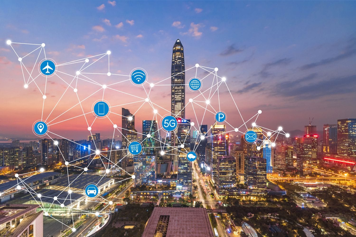
A smart city utilizes technology and information communication to enhance operational efficiency and competitiveness, benefiting both current and future generations. These cities connect various aspects of the city, including transport, health, service delivery, security, disaster response, and resource management, aiming for sustainability and improved quality life for present and future generations.
The Geospatial Backbone of Smart Cities
Spatial data is crucial in a smart city, enabling sustainable decision-making by integrating physical, digital, and human systems, thereby enhancing flexibility and adaptability in urban management. AI-integrated Geographical Info Systems, or GIS platforms, sensors and 5G technologies are now leveraged in the design of smart cities to serve as traffic monitors, utility managers, and emergency-response coordinators.
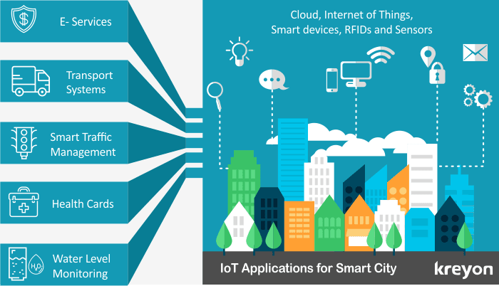
Transport Management: The smart cities are leveraging AI and GIS to efficiently manage traffic data, enhancing efficiency and reducing congestion by using historical and real time traffic data for example by recording live traffic data and adjusting traffic signals in real time. Geospatial analysis can also be used in understanding roads that need attention, repairs, expansion, construction and even in route management in the case of public transportation and optimising traffic flow and management within cities.
Utility Management: AI technologies, combined with geospatial data, are revolutionizing utilities management by predicting maintenance needs & costs, enhancing efficiency, and ensuring efficient use and distribution of resources such as water, electricity and gas.
Emergency Response: Geo AI technologies can improve the accuracy of emergency and disaster awareness, mapping and preparedness. This helps in optimizing resource allocation and responses in disasters such as floods, fires and public health emergencies. Research has also shown that Geo AI smart cities based technologies do not only improve the safety and resilience of cities but are providing a new way of intelligent digital transformation of cities.
Sustainable Development: Accurate tracking and mapping of resource use, population dynamics, needs and movements help in effective resource management and improving the quality of life of the citizens and those of future generations.
There are also many examples of the use of geomatics in many emerging smart cities technologies such as ride – hailing apps like Uber, Indrive, self-driving vehicles and augmented realities.
Geomatics and the UN Sustainable Development Goals (SDGs)
Geomatics has an active role in supporting the United Nations Sustainable Development Goals (UN SDG Goals) through geospatial data collection and mapping technologies that are very essential in effective monitoring, visualisation, analysis and making data driven decisions. Geomatics in smart cities offer location based insights and interconnectedness of the various social, economic and environmental aspects of the city for a better and sustainable life. It is critical in many of the SDGs that are not only limited to:
SGD 2 (Zero Hunger)
Did you know that , ⅓ of the world’s food (1.3 billion tonnes) produced yearly is lost yet millions of people worldwide are malnourished or starving to death every day? According to a report by the Natural Resources Defense Council, 40% (US$165 billion) of U.S. food is wasted each year as it goes uneaten yet it is even sufficient to feed millions of Americans every year. This is also the case with some urban cities and communities as they lack the connection, infrastructure and network to get the food to those who might need it. According to the UN, it is projected that more than 600 million people worldwide will be facing hunger in 2030, posing a challenge to the SDG Goal Number 2 and something ought to give.

Smart cities can contribute to the SGD 2 by using technology, IoT and AI to improve agriculture, reduce food waste, track food distribution and ensure an equitable access of food for all city residents. Smart applications and websites can help in food distribution by linking farmers to markets, food sellers to consumers and integrating with other technologies and data to minimize food wastages. A good example is the Food for All application that reduces restaurant food waste in Boston and NYC by connecting customers with meal discounts up to 80%. Users can explore deals, schedule pickups, and donate food via the app.
Food related data can be mapped and analyzed to review production outputs, storage, consumption patterns and food insecurity to inform food related challenges. The main aim will be to understand current issues and opportunities to create more inclusive and sustainable food systems. Another example of use of modern technology in food preservation and reducing wastage is Zimbabwe’s first AI and IoT powered grain silos in Kwekwe that can automatically monitor and adjust conditions such as temperature, moisture and humidity to avoid grain spoilage and pests.
SGD 6 (Ensure Availability and Sustainable Management of Water and Sanitation For All)
Despite making huge strides globally in clean water provision, one in every three people are without sanitation making it a major contributor to unnecessary diseases and deaths. Smart cities water management can contribute to this goal by using technology such as AI, IoT and geospatial data analytics to monitor and control water resources with great efficiency, sustainability and resilience. Hydrographic surveys can be used to map water bodies such as rivers, data and coastal areas providing the much needed data for water resource management.
Sustainable use and allocation of fresh water resources can be efficiently supported by monitoring the water quality & quantity and environmental pollution along the various water bodies and channels. Sanitation in smart cities is greatly improved by using sensor equipped waste bins, optimising waste collection routes and AI enabled data analytics to reduce costs, improve waste management efficiency and promote recycling and other smart waste disposal technologies.
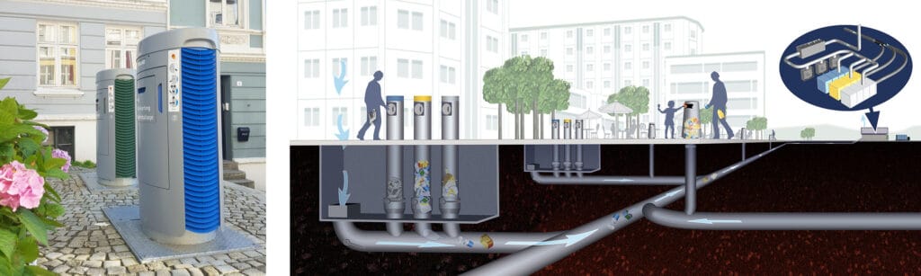
A good example of smart city waste and sanitation management is the Envac waste technology that allows for automatic waste collection through an underground vacuum pipe network to a remote waste dump site away from the city thereby reducing air pollution, traffic congestion and costs for a more efficient waste collection process.
SGD 11 (Make Cities and Human Settlements Inclusive, Safe, Resilient and Sustainable)
The world is increasingly urbanizing, with over 55 % of the world’s population currently living in cities. By 2050, this percentage is projected to increase to approximately 68 % to 70 %. As the world population is constantly increasing, there is a need to create cities and human settlements that are safe, resilient and sustainable. The goal is not necessarily on smart cities but smart technologies and applications such as urban planning, green building and efficient public transportation as a key component in coming up with safe, resilient and inclusive cities.
SDG 13 (Take Urgent Action to Combat Climate Change and Its Impacts)
Last year, 2024, the global temperature broke records and temporarily exceeded the 1.5°C threshold, highlighting the urgent need to curb greenhouse gas emissions. In the past 16 years severe weather incidents led to major displacements, food shortages, economic damages, and social unrest, yet capping global warming at 1.5°C is still possible. Remote sensing technologies are very important for monitoring deforestation, quantifying biomass and carbon emissions, land use changes, tracking climate change and assessing water quality, etc. This data is important for developing climate change mitigation strategies and policies.
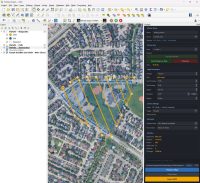
From Satellites to Street Sensors: Data That Builds a Smart City
Satellites play a critical role in smart cities from data collection to enabling communication and navigation within the cities. They provide the core of the city’s modern position, navigation and timing system like Global Navigation Satellite System (GNSS) that allows for services such as transport and logistics and communication networks of various smart cities applications and systems.
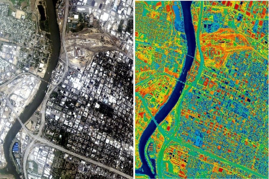
Satellite data can be very important for urban planners by providing an aerial view of the city and help in mapping, tracking and monitoring urban development and expansion. Through a combination of historical data and recent satellite data with AI models and data analytics, a wide range of information, simulations and predictions can be done. This enables data driven decision making for sustainable smart cities objectives.
U-net (a fast and precise convolutional neural network) can be used for tracking land use in cities from satellite data with great precision that people and firms, as well as zoning governance, can allocate distinct economic activities to separate plots of land. Satellite service providers such as EOS Data Analytics provide advanced real time and historical satellite data enabling applications and analytics in various smart cities needs from boundary detection, land use changes, forest monitoring, carbon projects, disaster response, environmental and many others.
Water resources and quality management in smart cities is enabled by using satellite data and various sensors to estimate parameters such as turbidity, water surface temperature, chlorophyll and suspended sediment. EOMAP is offering satellite based water analytics that can track key parameters dating back 40 years which can help stakeholders understand and monitor seasonal trends and come up with alert workflows. The key parameters include; chlorophyll, Harmful Algal Bloom Indicator, Coloured Dissolved Organic Matter, Trophic State Classification, Water Surface Temperature and Turbidity and Total Suspended Matter.
Satellite data can be sourced from a variety of free and paid platforms and they vary in capabilities, sensors, repeat times, access and use. It is important to find the one that suits the city’s needs and budget for optimized efficiency.
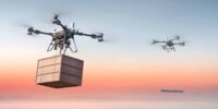
Drones play an important role in smart cities management from real time monitoring of infrastructure to mapping and generation of accurate 3D models, maps and digital twins of streets, buildings and other infrastructure. By using drones, digital twins are updated in real time to match the changing urban conditions.
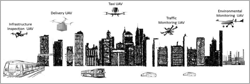
For example after an earthquake, drones can be deployed to map the damage and give updated maps and models making sure that the digital twin is always up to date. Drones equipped with surveillance cameras can also be used to maintain order during city events or in the streets and traffic control by offering real live feed and now coupled with some AI software traffic violations and crimes or dangerous behaviours can be curtailed.
Smart cities are enabled by various street sensors that are interconnected for a better quality life. These can include street cameras, radar and motion detector sensors to monitor & count traffic and pedestrian flow to reduce congestion and enhance safety. The traffic can then be controlled from a centralized system to optimize efficiency.

Other sensors such as air quality, temperature and humidity sensors can also help in managing the health and environmental aspects of the city and in weather forecasting for a safe and sustainable living. If for example areas that might have increased poor air quality, mitigation efforts can be implemented or sources of pollution be identified and appropriate actions taken such as fining or closure of the premises.
By combining real-time data from satellites, drones and other street sensors with historical and environmental data, digital twins can forecast traffic congestion, infrastructure deterioration, or even the consequences of city expansion. This ability enables city planners to implement proactive actions, lowering risks and improving urban resilience.
Current Trends & Future Outlook
Year by year, cities are becoming smarter as they collect data from citizens, gadgets, environment and assets to manage available resources more efficiently. According to Statista, the smart cities worldwide revenue was projected to reach US$79.94bn in 2025 with a compound annual growth rate (CAGR) of 9.23% from 2025 to 2030. Singapore and South Korea are among the countries leading in implementing smart city initiatives with the United States expected to generate a revenue US$27.06bn in 2025 from smart cities.
The IMD Smart City Index is an annual Smart City Index ranks smart cities according to their resident’s perceptions on the economic, technological and humane (quality of life, environment, and inclusiveness) aspects. According to the 2025 IMD Smart City Index, Zurich topped the list, followed by Oslo, Geneva, Dubai and Abu Dhabi on the 5th. The full report can be downloaded here, and below I have attached a snippet of the report, showing the top 20 countries.
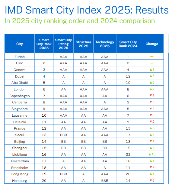
Adapted From IMD Smart City Index 2025 Report
There are many other key trends, technologies and components that have championed the smart cities and are likely to contribute to its future outlook. These are but not only limited to:
Predictive analytics is at the hallmark of smart cities, enabling city planners to anticipate and respond to the urban challenges with great efficiency. It is supported by collection of data, integration of data from multiple sources, artificial intelligence and machine learning algorithms that are learning from historical data and then make present and future predictions.
Internet of Things (IoT) is a great enabler of smart cities by allowing its network of objects like gadgets, vehicles and appliances fitted with various software, sensors and technologies to communicate and share data over the internet. This allows smart cities to improve on their governance, citizen engagement, logistics, mobility, safety, health and sustainable use of resources.
IoT devices can find its application in air and water quality management within the cities by providing the necessary data and sending it to the relevant stakeholders for a more detailed planning and mitigation.
Geospatial intelligence is playing a critical role as authorities and urban planners in smart cities make data-driven decisions in areas like environmental management, transport management, infrastructure development, disaster response and resource allocation. This is done through its ability to collect, analyze and interpret the earth’s geospatial data from various sources such as roads, buildings, rivers, IoT sensors, social media e.t.c to create valuable insights for city management.
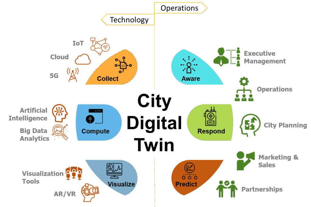
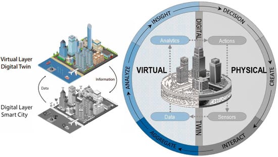
3D Models & Digital Twins have been actively used in smart cities management to help link the physical world to the virtual one. The only difference between the tool is that the 3D models are the static 3 dimensional representation of the city whilst the digital twin is the dynamic view of the same that combines real time data from IoT sensors to create a live simulation of the city. Digital twins are very important in smart cities as they can be used for simulation such as traffic flow, flood response and can also be a great tool in citizen engagements and participation through interactive views of proposed developments.
A good example of a digital twin, is the Virtual Singapore, which is a high resolution 3D representation of the whole nation. It includes above ground features such as roads, green spaces and buildings as well as underground utilities. Singapore also has various other digital twins for its different projects such as: PUB’s Anomaly Leak Finder (ALF) – digital twin of the water network, Grid Digital Twin: a digital twin of the power grid, Maritime Digital Twin (MDT): a real-time representation of its maritime operations and port infrastructure.
Open and Crowdsourced Data with a combination of AI has led to the success of smart cities. They help in providing large and accurate volumes of data that helps AI systems in coming up with accurate models, analyses and predictions. Open data can be referred to the publicly accessible information such as real-time information on transport, pollution, and utilities whilst crowd sourced data refers to the user-generated information giving real-time insights on the city dynamics such as traffic conditions, infrastructure problems, safety and health issues.
All these are important to the city for their increased transparency, efficiency and decision making processes. Barcelona city, has been leading on the open data for participatory activities such as budgeting, policy debates, problem solving consultations and urban innovation through its online platforms and apps.
Cloud-based Mapping Platforms are a great enabler of smart cities through collection, storage, analysis and visualization of the large datasets from various sensors, IoT devices, open and crowdsourced data. Cloud-based mapping platforms have a great advantage over the traditional desktop GIS based mapping as they bring in real time data processing, scalable functions, massive cloud storage and collaborations between various smart city stakeholders.
A good example is Esri’s GIS smart community information system that allows its users to reduce costs, improve response times and support effective decision making and policy across various city stakeholders.
Another case study is the the Iowa Track-A-Plow website that integrates various sensors, including GPS for vehicle tracking, salt spreader and engine operation sensors, over 430 truck-mounted cameras, 700 CCTV cameras, infrared temperature sensors, 75 weather stations, third-party traffic data, road condition reports, and 300 digital message signs. The public plays a larger role in road safety and the real-time understanding of conditions through the platform helps individuals and businesses make better driving choices
Conclusion: Mapping the Future of Sustainable Cities
Geomatics’ power rests in its capability to integrate and connect the various datasets and turn them into informative comprehensive spatial dashboards that can help policy markers and relevant stakeholders in understanding, analyses and real time visualization of their progress towards attainment of the SDGs. Geomatics helps in promoting evidenced based governance, tracking and intervention of the SDGs thereby making smart cities a reality.
With the growing interest and development of smart cities, data privacy and security issues cannot be ignored. The extensive data collection in smart cities for visualisation, decision making and predictive analytics raise concerns about citizen’s privacy. To protect the information of their inhabitants, smart cities must have strong data security and protection procedures.
There are also other challenges that smart cities experience, that include: high setup & operational costs, lack of supporting infrastructure, integration challenges, prohibitive legislation, red tape & bureaucracy and lack of skilled labour. The challenges need to be considered and addressed for the success of smart city initiatives.
The smart cities evolution is on rise and there is a need to learn, collaborate and innovate to realise its full benefits. “The cities of tomorrow will be built not by concrete, but by coordinates.”


