
DJI has announced recent updates on its geofencing systems (GEO) that applies to most of it’s consumer and enterprise drones in the United States on their apps, both the DJI Fly and DJI Pilot. The changes took effect from the 13th of January 2025 and follow similar changes implemented in the European Union (EU) in 2024 to provide pilots with more freedom to fly yet still aligning with the existing drone regulation by the European Aviation Safety Authority (EASA) and the UK Civil Aviation Authority (CAA). The updates are also aligning with Federal Aviation Administration (FAA) Remote ID objectives.
What it Means
- Areas previously defined as Restricted Zones (or No-Fly Zones) will be displayed as Enhanced Warning Zones, aligning with the FAA’s designated areas.
- In these zones, the DJI fly apps will show in-app alerts to notify operators they are flying near FAA designated controlled airspace.
- However, they won’t prevent the operator from flying the drone in that previously Restricted, or No-Fly Zone area.
- DJI is moving in line with the FAA regulatory principles of the drone operator bearing final and ultimate responsibility, placing back controls in the hands of the drone operators.
- DJI also suggests the FAA’s mandated RID function on drones being flown today negate the need for their DJI geofencing feature.
How To Update
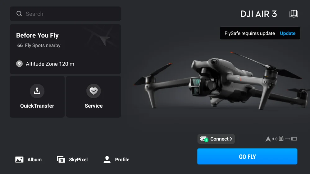
- To update, drone operators need to connect their flight app to the internet and click ‘Update’ on the FlySafe pop-up notification as shown in the image below.
Brief History
DJI first introduced the GEO system in 2013 when consumer there were few official drone flight rules and regulations because consumer drones were still a relatively new technology. In order to promote responsible flying behaviors and stop DJI drone pilots from unintentionally flying in restricted airspace, such as around government facilities, airports, or prisons, the geofencing system was developed as a voluntary built-in safety feature.
Ever since there have been significant changes with regards to global regulations and user awareness with main focus on geo-awareness and Remote ID solutions that make detection and enforcement much easier. National aviation authorities, such as the European Aviation Safety Authority (EASA) in the EU, the UK Civil Aviation Authority (CAA), and the FAA in the U.S., have established comprehensive geographical zones for unmanned aircraft systems (UAS) and enforce drone regulations.
Remote Identification of Drones
Remote ID is the ability of a drone in flight to provide identification and location information that can be received by other parties through a broadcast signal.
The safety and security framework required for increasingly intricate drone operations is established by Remote ID. When a drone seems to be flying dangerously or in an area where it is not permitted to fly, Remote ID also assists the FAA, law police, and other government authorities in locating the control station. Drones which are required to be registered or are registered, including those flown for recreation, business, or public safety, must comply with the rule on Remote ID.
Get These Facts
Following the recent updates, there has been some misconceptions of the information going in the circles and DJI has had to issue clarification on their View Points blog to give out the facts on the recent updates as summarized below. The full clarification to dispute the misinformation and set the record straight can be found on their blog post here.
- FACT 1: Politics does not drive safety decisions at DJI.
- FACT 2: Aviation regulators around the world – including the FAA – have advanced the principle of operator responsibility. This GEO update aligns with and respects this principle.
- FACT 3: The GEO system has always been an educational – not an enforcement – tool. The GEO system has also not been removed; warning zones and in-app alerts remain in place to continue educating pilots on safe flight operations. This change gives back control to operators and provides them the information they need to fly safely.
- FACT 4: In addition to aligning with the FAA’s operator responsibility-led principles, the update to “Enhanced Warning Zones” provides two operator benefits: Reduced operational delays for pilots and improved consistency with official FAA data.
In Conclusion
- DJI reminds pilots to always ensure flights are conducted safely and in accordance with all local laws and regulations.
- For flights conducted in Enhanced Warning Zones, drone operators must obtain airspace authorization directly from the FAA and consult the FAA’s No Drone Zone resource for further information.


